In this article
- Choquequirao trek at a glance
- Route map and elevation profile
- Choquequirao trek routes compared
- How hard is the Choquequirao trek?
- Training and altitude
- Choquequirao trek itinerary (4 days / 3 nights)
- Campsites on the Choquequirao trek
- What you will see at Choquequirao
- History of Choquequirao
- Wildlife and plants
- Best time to hike Choquequirao
- Is there a cable car to Choquequirao?
- Do you need a permit or a guide?
- What to pack
- Frequently asked questions
Choquequirao is one of the largest Inca sites in Peru and one of the least visited. Its name means “cradle of gold” in Quechua, and it is often called the sister of Machu Picchu. There is no road and no train: you reach it on a demanding trek down into the Apurímac canyon and back up the other side. That is exactly why, on most days, you share the ruins with only a handful of other hikers.
This guide covers the route and elevation profile, the different ways to do the trek, how hard it is and how to train, the 4-day itinerary, the campsites, the history and wildlife of Choquequirao, the best time to go, the cable car project, the entrance fee and what to pack.
Choquequirao trek at a glance
- Start and end: Capuliyoc viewpoint (2,918 m / 9,573 ft), about 4 hours by road from Cusco, above the village of Cachora.
- Distance: about 40 km (25 miles) round trip in 4 days.
- Lowest point: Playa Rosalina, on the Apurímac river, 1,550 m (5,085 ft).
- Highest point: the main square of Choquequirao, 3,064 m (10,052 ft).
- Difficulty: challenging, because of the long descents and climbs, not the altitude.
- Permits: no daily quota like the Inca Trail; you only need the entrance ticket.
Route map and elevation profile
The trek is an out-and-back route. From Capuliyoc the path drops almost 1,400 m to the Apurímac river, then climbs more than 1,500 m on the other side of the canyon to Marampata and the ruins. On the way back you repeat the canyon in reverse.
- 39 kmhiking distance (24.2 mi)
- 3,064 mhighest point: Choquequirao (10,052 ft)
- +2,882 melevation gain from Capuliyoc
- km 0 Capuliyoc Start · view over the Apurímac canyon
- km 7 Chiquisca
- km 9 Playa Rosalina Camp 1 · Apurímac river
- km 12 Santa Rosa
- km 15.5 Marampata First view of Choquequirao
- km 19.5 Choquequirao Camp 2 · guided visit on day 3
- km 29.5 Playa Rosalina (return) Cross the Apurímac again
- km 32 Chiquisca (return) Camp 3
- km 39 Capuliyoc (end) Transport back to Cusco
Why other websites say 44 to 58 km
Our figure of about 40 km is measured from Capuliyoc, where the trail starts, and back. Other sites quote 44 to 58 km for the same trek because they count from the village of Cachora, below Capuliyoc, or they add side trips such as extra time around the ruins or a night in Marampata. The canyon and the climbs are the same; only the starting point and the extras change.
Choquequirao trek routes compared
There are several ways to hike to Choquequirao. The first three are out-and-back from Capuliyoc; the last one continues across the Vilcabamba mountains to Machu Picchu.
| Route | Days | What it involves | Best for |
|---|---|---|---|
| Classic trek (our tour) | 4 days / 3 nights | About 40 km from Capuliyoc. Camps at Playa Rosalina, Choquequirao and Chiquisca; guided visit on day 3. | Regular hikers who want a balance between effort and time at the site. |
| Slower version | 5 days / 4 nights | Shorter daily stages and an extra night near the ruins or in Marampata. | A full day at Choquequirao and less pressure on the climbs. |
| Fast version | 3 days / 2 nights | Same route with very long days and a shorter visit. | Very fit hikers with little time. |
| Choquequirao to Machu Picchu | 7 to 9 days | Down to the Río Blanco and up to Maizal (about 3,000 m), over the San Juan pass (about 4,100–4,200 m, also called Victoria) to Yanama, over the Yanama pass (about 4,660 m), then down to the Santa Teresa valley and the train to Aguas Calientes. | Experienced trekkers comfortable with high passes and remote camps. |
Altitudes on the long route vary slightly between sources, and some itineraries replace a section with a road transfer.
How hard is the Choquequirao trek?
It is one of the most demanding classic treks around Cusco. The altitude is moderate, always below Cusco, but the elevation changes are huge and come in long, steep sections without much flat ground.
The descent to the Apurímac
Day 1 is almost all downhill: about 9 km and nearly 1,400 m of descent on a dusty, zigzagging path. It is hard on the knees, so trekking poles are a must.
The climb to Marampata
Day 2 is the toughest: from the river at 1,550 m you climb to Marampata at 2,900 m, in the heat of the canyon. Start early, before the sun reaches the slope, and go slowly. From Marampata the path is gentler and you see Choquequirao across the valley.
Heat and sun
The bottom of the canyon is hot and humid all year, while nights near the ruins are cool. Sun protection and enough water make a bigger difference here than on most Andean treks.
The trek is a good fit for travelers who already hike regularly. If you want an easier first trek to Machu Picchu, look at the Short Inca Trail.
Training and altitude
Adding up the main climbs on our route (river to Choquequirao, river to Chiquisca and Chiquisca to Capuliyoc), you gain about 2,900 m in 4 days, and you lose roughly the same on the way down. Your legs and knees matter more than your lungs.
A simple 6-week plan
- Weeks 1–2: three 45–60 minute walks or runs a week with hills or stairs, plus two short strength sessions (squats, lunges, step-ups).
- Weeks 3–4: one 4–5 hour hike each weekend with real descents, using your poles and the boots you will wear in Peru.
- Weeks 5–6: two long hikes on back-to-back days. Add slow step-downs from a stair to prepare your knees.
- In Cusco: spend at least two days in the city first. Cusco is higher than any point on the route, so that is enough to adapt.
Altitude sickness is rarely the problem on this trek, because the route stays between 1,550 m and 3,064 m. The real risks are heat, dehydration and sore knees on the descents.
Choquequirao vs Inca Trail vs Salkantay
| Trek | Days | Distance | Max altitude | Climbing |
|---|---|---|---|---|
| Choquequirao (our route) | 4 | About 40 km | 3,064 m | About 2,900 m in total, in two long canyon climbs |
| Classic Inca Trail | 4 | About 40 km | 4,215 m (Warmiwañusca pass) | One long climb to the high pass on day 2, then smaller passes |
| Salkantay | 4–5 | About 70 km | About 4,650 m (Salkantay pass) | Climb to the pass on day 2, then a long descent towards the jungle |
| Short Inca Trail | 2 | About 11 km | 2,720 m (Inti Punku) | About 550 m |
In short: Choquequirao is the hardest on the legs, while the Classic Inca Trail and Salkantay are harder because of the altitude. For a gentler option, read about Short Inca Trail difficulty.
Choquequirao trek itinerary (4 days / 3 nights)
Day 1: Cusco – Capuliyoc – Playa Rosalina
Early drive from Cusco to Capuliyoc, with the first views of the Apurímac canyon. Meet the muleteers and descend about 9 km past Chiquisca to the campsite at Playa Rosalina, next to the river.
Day 2: Playa Rosalina – Santa Rosa – Marampata – Choquequirao
Cross the bridge and climb through Santa Rosa to Marampata, the first viewpoint over the ruins. Continue to the campsite near Choquequirao, about 10 km in total.
Day 3: Choquequirao – Chiquisca
Guided visit of the site: the main square, the ushnu platform, the water channels and the terraces of the llamas. In the afternoon, return to Marampata and descend to camp at Chiquisca.
Day 4: Chiquisca – Capuliyoc – Cusco
Final climb back to Capuliyoc and drive to Cusco, arriving in the evening.
 Choquequirao 4 days · cook and mules included
Choquequirao Trek 4 Days / 3 Nights
See itinerary & dates →
Choquequirao 4 days · cook and mules included
Choquequirao Trek 4 Days / 3 Nights
See itinerary & dates →
Campsites on the Choquequirao trek
Campsites on the route are simple, and services can change from one season to the next. On our tour the cook and muleteers set up camp, so you only need cash for extras such as cold drinks.
| Campsite | Altitude | Basic services | On our 4-day tour |
|---|---|---|---|
| Chiquisca | 1,900 m | Small campsite with simple lodging and a small restaurant. | Camp 3 (night 3) |
| Playa Rosalina | 1,550 m | Campsite by the Apurímac river with toilets, cold showers and a small kiosk selling snacks. | Camp 1 (night 1) |
| Santa Rosa | 2,095 m | Family campsite with meals and a place to refill water on the climb. | Rest stop on days 2 and 3 |
| Marampata | 2,900 m | Small village with lodges, showers and meals; drinks and snacks for sale at higher prices than in Cusco. | Rest stop on days 2 and 3 |
| Choquequirao camp | 3,064 m | The closest campsite to the ruins, with toilets and cold showers. | Camp 2 (night 2) |
Phone signal along the route is limited and unreliable, so we do not list it by campsite. Some lodges in Marampata have offered paid Wi-Fi, but do not count on being connected during the trek.
What you will see at Choquequirao
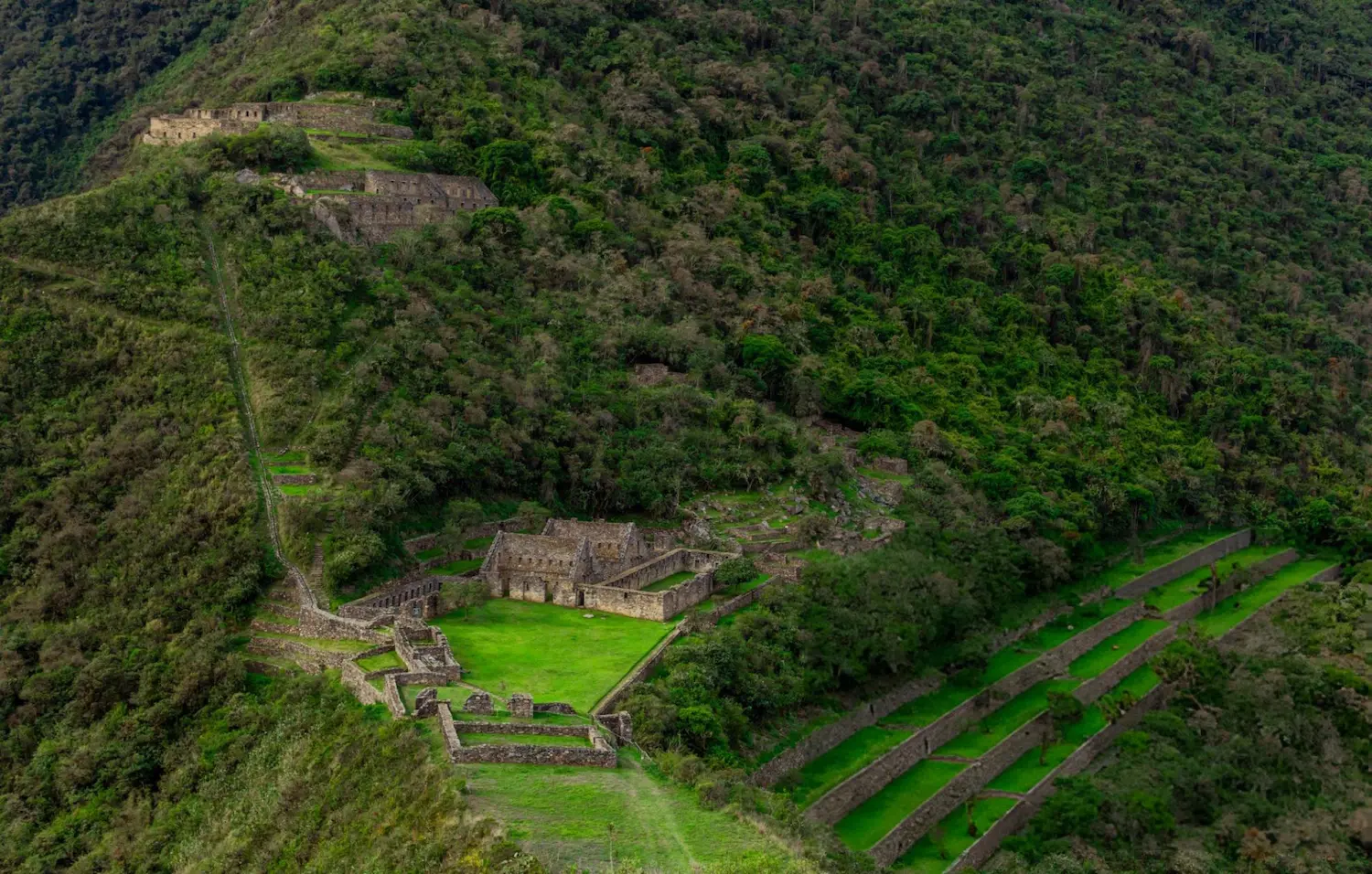
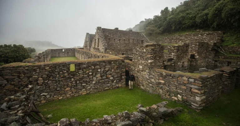
- The main square and ceremonial buildings, with two-storey houses and gabled walls.
- The ushnu, a ceremonial platform on a levelled hilltop with views in every direction.
- The terraces of the llamas, where more than 20 llamas made of white stone decorate the walls. It is one of the most unusual sights of Inca architecture.
- Canals and fountains that still carry water through the site.
Only part of the site has been excavated, so much of Choquequirao is still covered by forest. Compare it with Machu Picchu in Choquequirao vs Machu Picchu.
History of Choquequirao
An Inca site in the Vilcabamba mountains
Choquequirao sits on a ridge above the Apurímac, in the Vilcabamba range. According to Peru’s Ministry of Culture, the Incas took control of this region under Pachacuti and his son Túpac Inca Yupanqui, and pottery from the earlier Killke culture shows that people lived here before them. Archaeologists estimate the main complex was built around 1450. The site is divided into an upper sector (Hanan) and a lower sector (Hurin).
The Vilcabamba refuge theory
After the Spanish conquest, the Incas of Vilcabamba resisted in these mountains from 1537 to 1572: Manco Inca and his sons Sayri Túpac, Titu Cusi Yupanqui and Túpac Amaru I, who was executed in 1572 by order of Viceroy Francisco de Toledo. Local tradition held that Choquequirao was Manco Inca’s refuge, and in the 19th century the geographer Antonio Raimondi thought it was Vilcabamba, the last Inca capital. Today most researchers place that capital at Espíritu Pampa, further into the Vilcabamba mountains.
Early visitors and Hiram Bingham
A 1768 description of the provinces of Cusco by Cosme Bueno already mentions a ruined stone town called Choquequirao across the Apurímac, reached from Cachora. The French traveler Eugène de Sartiges later described the ruins in a magazine published in 1851. In 1909 the American explorer Hiram Bingham visited Choquequirao on a mule journey from Cusco to Lima. He doubted it was the last Inca capital, and that doubt led him to organize the 1911 Yale Peruvian Expedition, the trip on which he reached Machu Picchu.
Excavation and the llama terraces
Systematic excavation began in 1993. By 2023, according to the Ministry of Culture, about 60% of the architectural remains found had been restored; the rest is still under forest. The llama terraces were the big discovery of the 2000s: the first six figures were recorded in 2002, sixteen more were found in 2004 and, by 2005, the count of decorative figures had reached 28. In December 2024 the Ministry of Culture finished restoring 187 terraces in the Paqchayoq sector after four years of work. Choquequirao is the main site of the Choquequirao Archaeological Park, which covers more than 522,000 hectares.
Wildlife and plants
The forests around the ruins are part of the Choquequirao Regional Conservation Area, created in 2010 to protect the ecosystems of this part of the Vilcabamba range.
- Andean condor. The regional government calls it an emblem of Choquequirao. Condors live in the canyon and are sometimes seen gliding over the ruins, especially late in the day.
- Spectacled bear. The Andean bear is the most representative species of the conservation area. Residents of Santa Rosa and Marampata report regular sightings, and claw marks have been seen on the Inca terraces. Sightings are never guaranteed.
- Hummingbirds. More than 200 bird species have been recorded in the area, including the giant hummingbird, the largest in the world, and hummingbirds found only in southern Peru.
- Orchids. 196 orchid species have been recorded in the conservation area, including in the forests along the trail between Playa Rosalina and Marampata and inside the archaeological park.
Lower down, around Playa Rosalina, Santa Rosa and Chiquisca, you walk through dry forest with bromeliads on the trees. Near the ruins it turns into greener montane forest.
Best time to hike Choquequirao
The best months are April to October, the dry season, with stable weather and dry trails. From November to March it rains more often and the steep sections become slippery. Heavy rain can also close the trail: in 2026 the site was closed from 1 February to late April (it reopened around 22–23 April), during the rainy season, for maintenance work on the access path. More in how to get to Choquequirao and the best time to go.
Is there a cable car to Choquequirao?
Not yet. The Peruvian government is promoting a cable car project, built as a public-private partnership, that would cut the access to around 20 minutes. Its total concession cost is estimated at about USD 442 million. As of late 2026 the project is still in the tender process, and works are not expected to start before 2027 (read the full Choquequirao cable car update). For now, the only way to reach Choquequirao is on foot, which is what keeps it so quiet.
Do you need a permit or a guide?
There is no permit quota like on the Inca Trail: you pay the entrance ticket at the control point, and it is included in our tour. It is possible to hike independently, but the trail is remote, there are few services between campsites and the phone signal is limited. With a guided trek, a cook prepares the meals, mules carry the camping equipment, an emergency horse travels with the group and your guide explains a site that has almost no information panels.
Choquequirao entrance fee
Under the Ministry of Culture’s official tariff schedule (in force since January 2025 and still the reference in 2026), the ticket for the Choquequirao Archaeological Park costs S/ 60 for adults, S/ 30 for university and technical students and S/ 25 for minors. Visitors aged 60 or over, teachers and people with disabilities pay half the general rate. The ticket is included in our tour; you only need to carry your original passport.
What to pack
- Original passport (checked at the control point).
- Broken-in hiking boots and trekking poles (you can rent poles from us for US$20).
- Sleeping bag rated around 0 °C / 32 °F (available for rent: US$20). The sleeping mat is included.
- Sun hat, sunglasses, high-factor sunscreen and insect repellent.
- Rain jacket and a warm layer for the nights.
- Reusable water bottle and water purification tablets.
- Headlamp and some cash in soles for drinks and tips.
Frequently asked questions
How long is the Choquequirao trek?
About 40 km (25 miles) round trip from Capuliyoc, usually done in 4 days. There are also longer treks that continue from Choquequirao to Machu Picchu in 7 to 9 days.
What is the elevation of Choquequirao?
The main square is at 3,064 m (10,052 ft). The trek starts at 2,918 m and drops to 1,550 m at the Apurímac river before climbing to the ruins.
Is Choquequirao harder than the Inca Trail?
Yes, in terms of effort. The Classic Inca Trail reaches a higher altitude (4,215 m), but Choquequirao has longer and steeper descents and climbs, often in the heat of the canyon.
Can I do Choquequirao in 3 days?
Yes, but it is very demanding and leaves less time at the ruins. We recommend 4 days to enjoy the site without rushing.
How many people visit Choquequirao?
Very few compared with Machu Picchu: usually a few dozen hikers a day, even in high season. The site receives up to about 9,000 visitors a year, most of them foreign travelers.
How much is the Choquequirao entrance fee?
Under the Ministry of Culture’s official tariffs, S/ 60 for adults, S/ 30 for university and technical students and S/ 25 for minors. It is included in our tour.
Where do you camp on the 4-day trek?
Night 1 at Playa Rosalina, by the Apurímac river (1,550 m); night 2 at the campsite next to Choquequirao (3,064 m); night 3 at Chiquisca (1,900 m).
Can I hike from Choquequirao to Machu Picchu?
Yes, on a 7 to 9-day expedition via Maizal and Yanama. It crosses two high passes, the highest at about 4,660 m, and ends in the Santa Teresa valley, where you take the train to Aguas Calientes.
Will I see condors or spectacled bears?
Condors live in the canyon and are sometimes seen over the ruins, especially late in the day. Spectacled bears live in the area, especially around Santa Rosa, but they are shy and sightings are a matter of luck.
Who discovered Choquequirao?
Nobody “discovered” it in the modern sense: colonial documents described it in the 18th century and local people knew of it. Hiram Bingham visited in 1909 and made it known abroad, two years before he reached Machu Picchu.